Military-Grade Drone Inspection for Critical Infrastructure: Bridges, Bunkers, and Airfields
India's rapid development and strategic imperatives place immense pressure on its critical infrastructure. From the intricate network of bridges connecting our cities to the vital airfields facilitating national connectivity and the secure bunkers safeguarding strategic assets, their integrity is non-negotiable. Traditional inspection methods, often manual, time-consuming, and hazardous, are increasingly insufficient to meet the demands of scale, precision, and safety. This is where advanced drone technology steps in, offering a transformative approach. At AiRotor Labs, based in Ahmedabad, India, we specialise in delivering military-grade drone inspection of critical infrastructure, leveraging cutting-edge technology to ensure the longevity, safety, and operational readiness of these vital assets.
The term "military-grade" might evoke images of combat drones, but in the context of inspection, it signifies a commitment to unparalleled robustness, precision, reliability, and data security. It means employing systems designed to perform flawlessly in challenging environments, capture highly accurate and actionable data, and adhere to the strictest operational protocols – capabilities that are indispensable for inspecting assets of national importance.
What Defines "Military-Grade" in Drone Inspection?
When we talk about "military-grade" capabilities in drone inspection, we're referring to a set of stringent standards that go beyond typical commercial drone operations. It's not about using actual military hardware, but rather adopting the same principles of performance, reliability, and data integrity.
Firstly, it implies ruggedness and reliability. These drones are built to withstand adverse weather conditions, operate in environments with electromagnetic interference, and maintain stable flight in gusty winds, ensuring data acquisition even when human access is difficult or dangerous. Secondly, advanced sensor integration is paramount. We're talking about high-resolution RGB cameras, thermal imaging for detecting anomalies invisible to the naked eye, LiDAR (Light Detection and Ranging) for precise 3D mapping, and sometimes even multispectral sensors for material analysis. These aren't off-the-shelf consumer cameras; they are industrial-grade instruments capable of sub-centimeter accuracy. Thirdly, secure data handling and transmission are critical. For sensitive infrastructure, data integrity and protection against cyber threats are paramount. Finally, operational precision and repeatability are key. The ability to execute pre-programmed flight paths with extreme accuracy, and to repeat these missions over time for comparative analysis, is a hallmark of military-grade capability.
In the Indian context, operating such advanced systems also demands strict adherence to Directorate General of Civil Aviation (DGCA) regulations. This includes obtaining the necessary Unmanned Aircraft Operator Permit (UAOP) for commercial operations, ensuring all drones have a Unique Identification Number (UIN), and securing specific flight permissions, especially when operating near critical infrastructure or in controlled airspace. AiRotor Labs maintains full DGCA compliance, ensuring all our operations are legal, safe, and secure.
Bridges: Ensuring Structural Integrity and Public Safety
India's extensive network of bridges, from ancient stone structures to modern cable-stayed marvels, are lifelines for commerce and connectivity. Their continuous structural health monitoring is vital. Traditional bridge inspections involve scaffolding, rope access, or expensive crane lifts, leading to traffic disruptions, high costs, and significant safety risks for inspectors working at heights or over water.
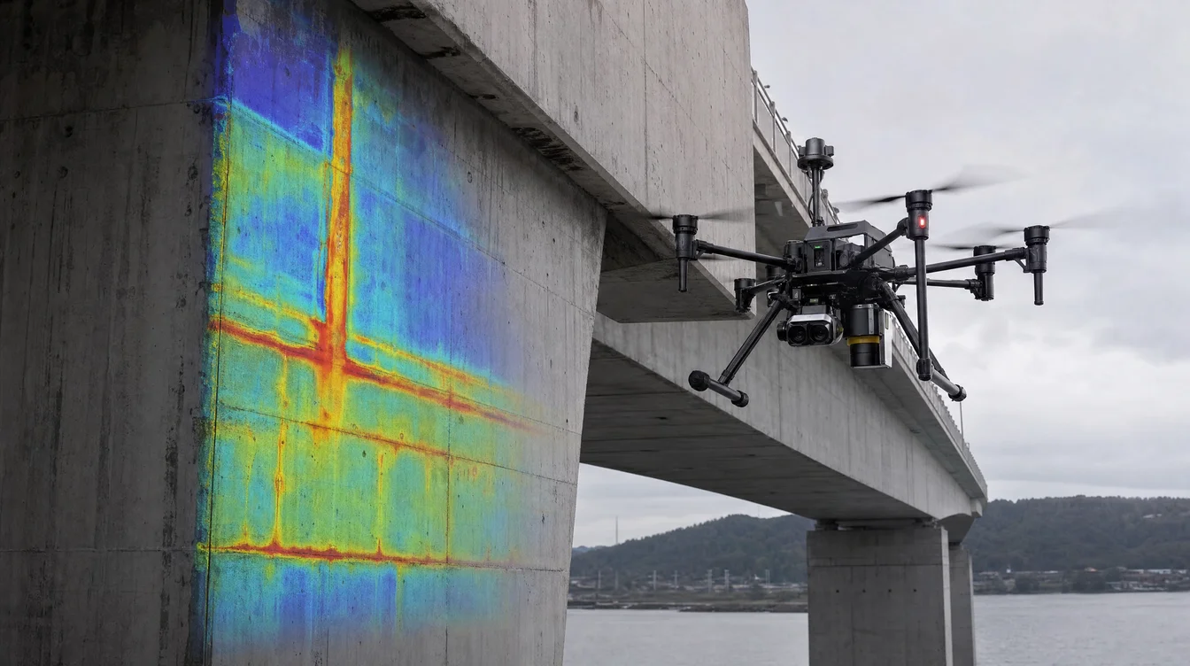
Military-grade drone inspection of critical infrastructure like bridges revolutionises this process. Drones equipped with high-resolution RGB cameras can capture detailed visual data of corrosion, cracks, spalling concrete, and other surface defects on girders, piers, and decks. Thermal cameras are invaluable for detecting subsurface delamination, water ingress, and other anomalies that might not be visible externally. LiDAR scanners create highly accurate 3D point clouds of the bridge structure, allowing engineers to detect subtle deformations, measure clearances, and monitor changes over time with centimeter-level precision (e.g., 2-5 cm accuracy for RTK/PPK enabled drones).
The benefits are substantial:
- Enhanced Safety: Inspectors remain safely on the ground, eliminating risks associated with working at height or in confined spaces.
- Reduced Disruption: Inspections can often be conducted without closing lanes or disrupting traffic flow, minimizing economic impact.
- Speed and Efficiency: A comprehensive drone inspection of a medium-sized bridge can be completed in a fraction of the time compared to manual methods, often in days instead of weeks.
- Data-Driven Decisions: The digital data collected (images, thermal maps, 3D models) provides an objective, quantifiable record for predictive maintenance and long-term asset management.
Bunkers and Fortifications: Covert Assessment and Structural Health
For strategic bunkers, military installations, and border fortifications, inspection presents unique challenges related to security, access, and the often covert nature of the assets. These structures are built for resilience, but even they require periodic assessment to ensure their structural integrity, detect potential vulnerabilities, and monitor for any changes.
Drones offer an ideal solution for inspecting these sensitive sites. Externally, high-resolution cameras can identify camouflage degradation, structural cracks, or erosion around the foundations. Thermal cameras can detect heat signatures indicative of internal activity or structural weaknesses, while LiDAR can create precise 3D models for detailed topographical analysis and change detection. For internal inspections of larger bunkers or underground facilities, smaller, agile drones equipped with collision avoidance technology and powerful lighting can navigate confined spaces, capturing visual and thermal data without endangering personnel or requiring extensive setup.
The "military-grade" aspect here is crucial for ensuring the data is secure, the operation is discreet, and the equipment can perform in potentially challenging or GPS-denied environments (for internal flights). AiRotor Labs' expertise ensures these operations are conducted with the utmost discretion and security protocols.
Airfields and Runways: Precision for Operational Readiness
Airfields are critical national assets, demanding meticulous maintenance to ensure safe and efficient aircraft operations. The vast expanses of runways, taxiways, and aprons are subject to constant wear and tear from heavy aircraft loads and environmental factors. Traditional ground surveys for pavement condition assessment are time-consuming and often require partial or full runway closures, leading to significant operational disruption and economic loss.
Military-grade drone inspection of critical infrastructure like airfields offers a superior alternative. Drones equipped with high-resolution cameras can rapidly map entire runways, capturing detailed images for the detection of cracks, spalling, foreign object debris (FOD), and other pavement distresses. This data can be processed to generate a Pavement Condition Index (PCI) with unprecedented speed and accuracy. LiDAR payloads are instrumental in creating precise digital elevation models (DEMs) of the airfield surface, essential for monitoring drainage patterns, identifying areas of ponding, and ensuring adherence to critical gradient specifications.
The ability to cover large areas quickly, often during off-peak hours or short operational windows, drastically reduces downtime. A comprehensive drone survey of an airfield can be completed in a matter of days, providing engineers with actionable data for maintenance planning and scheduling, far outstripping the weeks or months required for traditional methods. Given the strict DGCA regulations around airport operations, AiRotor Labs meticulously plans and executes these missions with prior permissions and close coordination with air traffic control (ATC) to ensure zero disruption to flight schedules.
The AiRotor Labs Advantage: Precision, Compliance, and Expertise
At AiRotor Labs, we understand the stakes involved in maintaining India's critical infrastructure. Our commitment to providing military-grade drone inspection of critical infrastructure extends beyond just advanced hardware. We combine:
- Cutting-edge Technology: Our fleet comprises industrial-grade drones equipped with the latest sensors – high-resolution RGB, thermal, and LiDAR – capable of capturing data with sub-centimeter accuracy.
- Expert Pilots and Analysts: Our certified drone pilots are highly trained in complex flight operations, and our data analysts are adept at processing vast datasets into actionable insights, detailed reports, and precise 3D models.
- DGCA Compliance and Safety: We operate strictly within DGCA guidelines, ensuring all necessary permits and safety protocols are meticulously followed, especially when operating near sensitive or high-security installations.
- Customised Solutions: We work closely with clients to understand their specific needs, designing bespoke inspection plans that deliver the most relevant and impactful data.
- Data Security: Understanding the sensitive nature of critical infrastructure data, we employ robust protocols for data acquisition, storage, and transmission.
By choosing AiRotor Labs, you are opting for a partner that brings unparalleled precision, efficiency, and safety to your infrastructure inspection needs. We are dedicated to helping India's vital assets remain robust, secure, and operational for decades to come.
Ensuring the longevity and safety of critical infrastructure is a continuous, demanding task. Leveraging advanced drone technology for military-grade inspection provides an intelligent, efficient, and safe solution to these challenges. From bridges and bunkers to airfields, drones are redefining how we monitor, maintain, and manage the backbone of our nation.
Ready to elevate the inspection standards of your critical assets? Contact AiRotor Labs today to discuss how our advanced drone inspection services can provide the precision, safety, and data insights you need.
Book Your Drone Inspection Consultation Now
AiRotor Labs provides drone-based inspection, aerial survey, and land survey across India.
Book a consultation →